---
title: Versioning CD's + Map Layers
description: Upload a construction drawing once, connect it to a map layer, and every revision updates in place automatically while keeping full version history.
---
[Skip to content](https://knowledge.sitemarker.com/versioning-cds-and-documents#main-content)
English
Show submenu for translations
![Rebrand Logo Mark No ISO.png\]](https://knowledge.sitemarker.com/hs-fs/hubfs/Rebrand%20Logo%20Mark%20No%20ISO.png?height=40&name=Rebrand%20Logo%20Mark%20No%20ISO.png)
Open main navigation
Close main navigation
- English
Show submenu for translations
- Go to sitemarker.com
Go to sitemarker.com
Hello. How can we help you?
- There are no suggestions because the search field is empty.
1. [Help Center](https://knowledge.sitemarker.com/?hsLang=en)
2. [Documents](https://knowledge.sitemarker.com/documents?hsLang=en)
3. [Document Management System](https://knowledge.sitemarker.com/documents?hsLang=en#document-management-system)
# Versioning CD's + Map Layers
## Connecting CDs to Map Layers (Auto Versioning)
Versioning is available in two separate areas:
- CD's
- Files
In each section, you are able to upload multiple versions of a document, image, KML, etc. and store it within the storage system. You can then view the history of the document and maintain the files as needed.
### CD's Versioning
Construction drawings change over the life of a project. Versioning lets you upload a revised drawing without losing the history of what came before, and if that drawing is being used as a map layer, SiteMarker keeps it in place automatically.
**How it works**
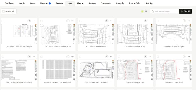
1\. Upload your construction document once, to the CDs tab. It will also show up in Files under the "Construction Documents" Folder.
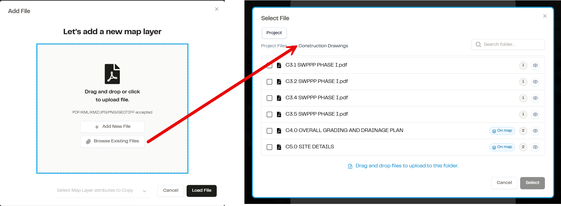
2\. When you add a map layer, choose **Browse Existing Files** and select the drawing you already uploaded. Position it on the map once, then save. [See here for more information on layer positioning](https://knowledge.sitemarker.com/how-do-i-add-layers-to-my-project#add-layer)
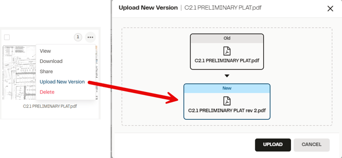
3\. When that drawing gets revised, upload the new version through the CDs tab like normal.
4. SiteMarker will ask, "Add this version as a map layer?", "Add as new map layer", or "Not now"
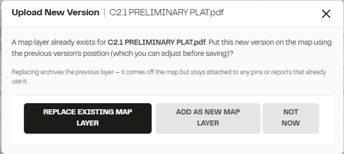
Choosing between replacing or adding as a new map layer is based on your desired result:
- **Replacing** archives the previous layer, it comes off the map but stays attached to any pins or report PDFs that already use it
- **Add as new** allows both versions to stay on the map. The previous version isn't deleted or replaced, it stays put alongside the new one. Toggle between them to compare what changed between revisions.
Confirm the desired option, and the new version drops into the exact same location, rotation, and scale as the version it's connected to. No re-aligning.
**Important:** the initial layer has to be added through Browse Existing Files for automatic version placement to work. If a layer was uploaded the old way (uploaded separately from the CDs/Files tab), new versions won't auto-place onto it.
**Why this matters:** one upload instead of two, the map always reflects the current drawing with no manual re-alignment, and old versions are preserved so you always have a record to compare against. This is built for any team working off plan sets that get revised over the life of a project; GCs, civil, SWPPP, inspections.
For the full walkthrough on adding a layer for the first time, see [How do I add layers to my project](https://knowledge.sitemarker.com/how-do-i-add-layers-to-my-project?hsLang=en).
- [Reports](https://knowledge.sitemarker.com/reports?hsLang=en)
- [Pins](https://knowledge.sitemarker.com/pins?hsLang=en#main-content)
- [Dropping pins](https://knowledge.sitemarker.com/pins?hsLang=en#dropping-pins)
- [editing - Directly or in Report](https://knowledge.sitemarker.com/pins?hsLang=en#editing-directly-or-in-report)
- [Exporting pins](https://knowledge.sitemarker.com/pins?hsLang=en#exporting-pins)
- [Workspaces](https://knowledge.sitemarker.com/workspaces?hsLang=en)
- [Projects](https://knowledge.sitemarker.com/projects?hsLang=en#main-content)
- [Add Members](https://knowledge.sitemarker.com/projects?hsLang=en#add-members)
- [Editing a Project](https://knowledge.sitemarker.com/projects?hsLang=en#editing-a-project)
- [Creating a Project](https://knowledge.sitemarker.com/projects?hsLang=en#creating-a-project)
- [Images](https://knowledge.sitemarker.com/projects?hsLang=en#images)
- [Layers](https://knowledge.sitemarker.com/projects?hsLang=en#layers)
- [Data Exports](https://knowledge.sitemarker.com/projects?hsLang=en#data-exports)
- [Members](https://knowledge.sitemarker.com/members?hsLang=en#main-content)
- [Profile](https://knowledge.sitemarker.com/members?hsLang=en#profile)
- [Permissions](https://knowledge.sitemarker.com/members?hsLang=en#permissions)
- [Notes / Meetings](https://knowledge.sitemarker.com/notes-meetings?hsLang=en#main-content)
- [Notes](https://knowledge.sitemarker.com/notes-meetings?hsLang=en#notes)
- [Meetings](https://knowledge.sitemarker.com/notes-meetings?hsLang=en#meetings)
- [Maps Screen](https://knowledge.sitemarker.com/maps-screen?hsLang=en#main-content)
- [Construction Drawing](https://knowledge.sitemarker.com/maps-screen?hsLang=en#construction-drawing)
- [Add/Edit Layers](https://knowledge.sitemarker.com/maps-screen?hsLang=en#add-edit-layers)
- [Dashboard overview](https://knowledge.sitemarker.com/maps-screen?hsLang=en#dashboard-overview)
- [Documents](https://knowledge.sitemarker.com/documents?hsLang=en#main-content)
- [Exporting to Site Marker](https://knowledge.sitemarker.com/documents?hsLang=en#exporting-to-site-marker)
- [Images](https://knowledge.sitemarker.com/documents?hsLang=en#images)
- [Document Management System](https://knowledge.sitemarker.com/documents?hsLang=en#document-management-system)
- [Dashboard features](https://knowledge.sitemarker.com/dashboard-features?hsLang=en#main-content)
- [Need Help? Section](https://knowledge.sitemarker.com/dashboard-features?hsLang=en#need-help-section)
- [Web Admin Dashboard](https://knowledge.sitemarker.com/dashboard-features?hsLang=en#web-admin-dashboard)
- [Offline Mode](https://knowledge.sitemarker.com/offline-mode?hsLang=en)
- [Integrations](https://knowledge.sitemarker.com/integrations?hsLang=en#main-content)
- [Trimble](https://knowledge.sitemarker.com/integrations?hsLang=en#trimble)
- [GNSS Recievers](https://knowledge.sitemarker.com/integrations?hsLang=en#gnss-recievers)
- [Autodesk](https://knowledge.sitemarker.com/integrations?hsLang=en#autodesk)
- [App Status](https://knowledge.sitemarker.com/app-status?hsLang=en)
- [AI](https://knowledge.sitemarker.com/ai?hsLang=en)
- [QR Signs and Dynamic Links](https://knowledge.sitemarker.com/qr-signs-and-dynamic-links?hsLang=en)
- [Layers](https://knowledge.sitemarker.com/layers?hsLang=en)
[](http://sitemarker.com)
sitemarker.com Help Center
[mailto:email@email.com](mailto:email@email.com)
Copyright © 2026, Site Marker Inc.